10 Real Estate Software Development Companies in 2026
- February 03
- 9 min

Space management is the discipline of organizing, tracking, and planning the physical spaces within a building or portfolio so that operational teams can allocate rooms, desks, and zones accurately and connect that spatial data to facility, booking, and portfolio workflows.
Most teams buying space management software discover they have paid for four layers of capability when their immediate need sits on just one of them. The floor plan layer is the foundation that makes everything else work. Booking systems, maintenance tasks, and utilization dashboards all read from that base. Without an accurate, editable floor plan, the layers above it run on guesswork. This article explains what space management covers, how the four layers stack on top of each other, and where each tool category enters the picture, so that teams can match investment to the job they need to do.
Key takeaways:
Space management describes how organizations track, plan, and allocate the physical spaces inside a building or across a portfolio. The term appears in facility management, corporate real estate, and workplace operations, and it covers a wider range of activities than most buyers expect when they first evaluate software.
The full scope of space management runs across four layers.
Layer 1: Spatial source of truth. This layer holds the floor plan model: rooms, desks, corridors, zones, and the hierarchy that maps buildings, floors, and individual spaces to each other. Every tool built above this layer reads from it. When the floor plan is accurate and editable, the systems that depend on it stay in sync. When the floor plan is a static PDF or an outdated drawing, every system above it starts from bad data.
Layer 2: Workplace experience. This layer covers desk and room booking, visitor management, hybrid attendance tracking, and interactive maps that help people find available spaces and reserve them. Tools in this layer present the spatial model to employees and building users in a way that supports daily decisions about where to sit and how to coordinate.
Layer 3: Facility operations. This layer handles work orders, preventive maintenance, asset registers, inspections, and vendor workflows that keep the building running. Maintenance tasks are pinned to physical locations in the floor plan. Assets are registered against the spaces they occupy. Inspection records reference the zone that was checked.
Layer 4: Portfolio and strategy. This layer connects occupancy data to lease obligations, chargeback calculations, and real estate portfolio decisions across multiple buildings or sites. Teams at this layer are asking whether a floor is underused, whether a lease should be renewed, and how to compare space cost across a portfolio.
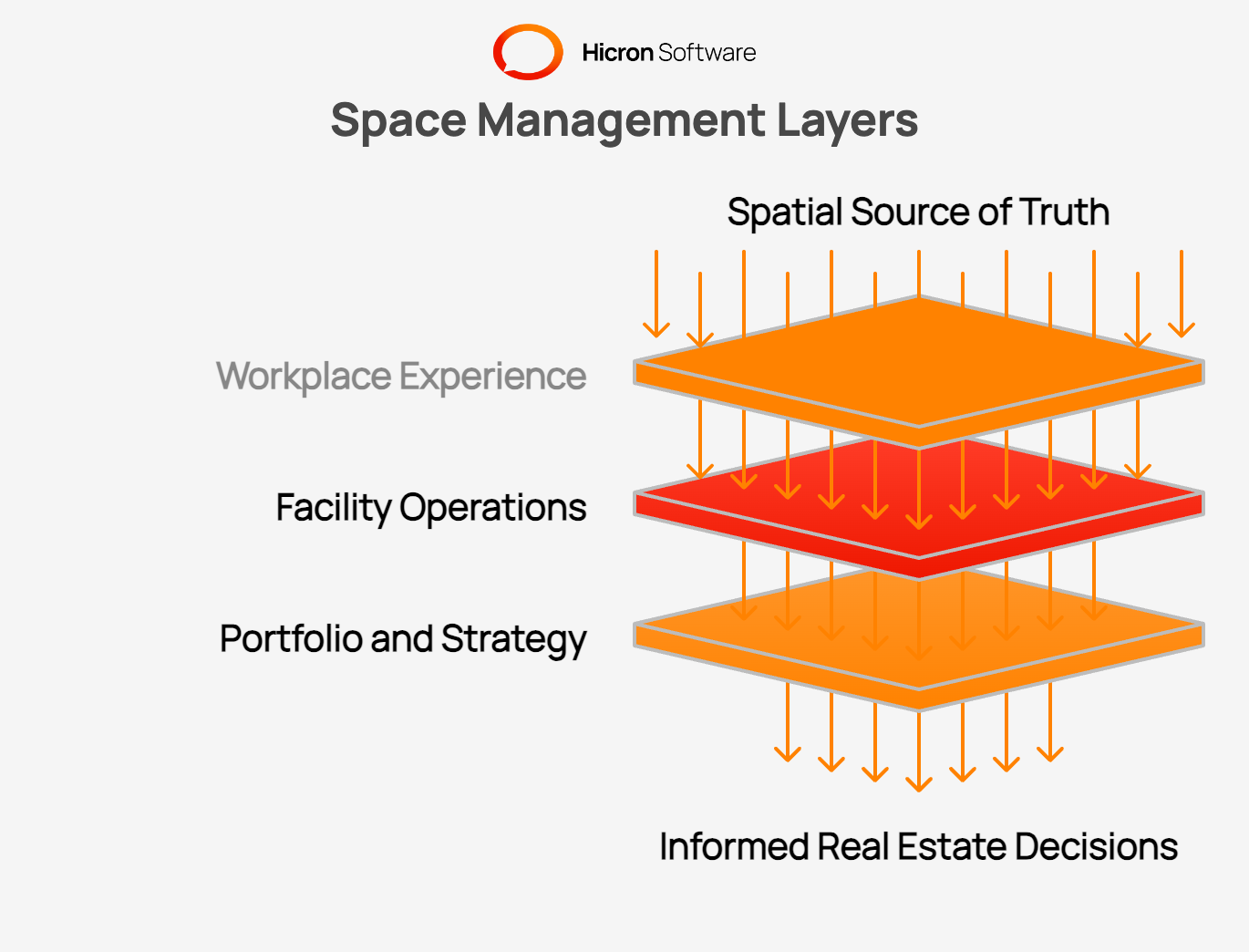
Full Integrated Workplace Management System (IWMS) platforms deliver all four layers. Most teams entering the market need layers one and two. Layer four becomes relevant when real estate decisions and lease obligations are central to how the organization operates.
Global office utilization averaged 54% in 2025, according to a JLL benchmark cited by FM:Systems. That figure reflects how much paid space sits unoccupied on a typical working day. Teams with an accurate, connected floor plan can identify which zones are underperforming and adjust allocation before committing to another lease cycle.
Every tool in the space management ecosystem reads from the floor plan layer. A desk booking system displays available desks by reading which desks exist and where they sit on the plan. A facility management platform pins a maintenance task to a physical location by reading the room it belongs to. A utilization dashboard identifies empty zones by reading the floor layout and comparing it against sensor or booking data.
When the floor plan layer holds accurate, editable spatial data, the tools above it work as designed. When the floor plan is a PDF in a shared drive, the tools above it require manual workarounds, data entry, and regular corrections to stay in sync with reality.
The practical consequence for teams evaluating software is this: the floor plan layer is the first problem to solve, and it is where the most friction sits. Most organizations already have a floor plan document. Architect exports, CAD files, and building PDF packages exist for almost every commercial space that has been built, renovated, or reconfigured. The gap is converting that document into a connected digital model that ops teams can edit and use without architectural training or specialist support.
Floor plan digitization is the process of converting an existing plan file into an editable digital model. Tools that address this problem specifically, such as HiSpatial, process an existing PDF or CAD export and return a 2D and 3D model in approximately 40 seconds. The ops team edits the result by clicking on the plan or by typing plain language instructions into an AI chat, and the full conversion runs inside the platform from the file the team already has.
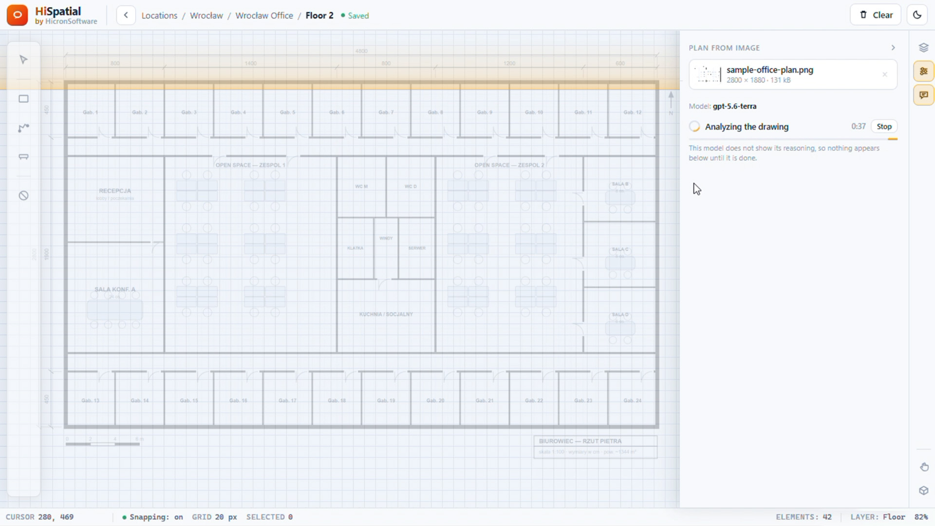
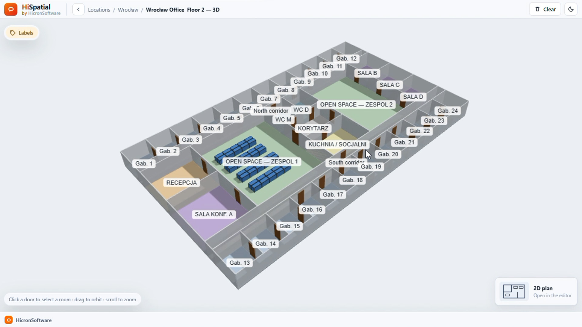
Enterprise IWMS platforms also deliver a floor plan layer, but they deliver it as part of a broader deployment that requires maintained CAD drawing libraries and a multi-month setup process. For teams whose immediate blocker is the floor plan itself, the lighter digitization path lets them start faster and connect to the booking or facility tools they already run.
Once a working floor plan exists, workplace experience tools connect to it to give employees and building users a spatial interface for reserving and navigating the space.
The tools in this layer are well established and widely adopted. What varies across teams is whether the floor plan layer underneath them is accurate, editable, and maintained. Booking platforms that include a manual floor plan editor allow teams to draw rooms inside the platform, yet manual drawing takes hours per location and produces a model that stays inside the booking tool rather than feeding other systems.
The third layer, facility operations, extends the spatial model into the workflows that keep a building running day to day.
The fourth layer, portfolio and strategy, connects occupancy and space data to financial decisions. This layer becomes relevant at the scale where lease renewals, chargeback to business units, and multi-site benchmarking affect how the organization manages its real estate.
Lease management tools track which spaces are leased, at what cost, on what terms, and when renewals fall due. Connected to the floor plan layer, they show how much of the leased area is being used and whether the lease commitment matches actual utilization.
Chargeback and cost allocation tools take occupancy data from the spatial and booking layers and assign space costs to the business units using them. The finance team sees the cost of each floor or zone attributed to the department that occupies it.
Portfolio benchmarking compares utilization and cost per square metre across multiple sites, using occupancy data fed from the layers below. Real estate strategy decisions, including whether to expand, consolidate, or exit a lease, draw from this layer.
The gap between target and actual utilization illustrates why this layer matters in practice. According to Skedda’s space management research, 79% of organizations target at least 65% utilization, yet the reported actual average sits at 38%. Portfolio benchmarking tools make that gap visible across sites and connect it to the lease and cost data needed to act on it.
Platforms that deliver all four layers include FM:Systems, MRI Software Workplace Central, and Planon. Each requires an enterprise license, a multi-month implementation, and a maintained drawing library as the input to the spatial layer.
AI tools are now active at each of the four layers of office space management, and the changes are most visible where manual work was previously the only option.
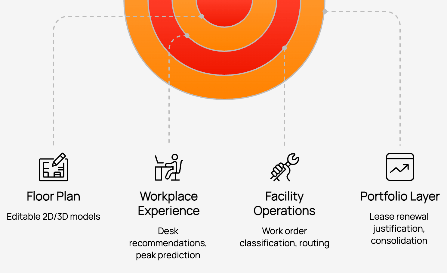
At the floor plan layer, AI converts uploaded plan files into editable 2D and 3D models in approximately 40 seconds. The system reads walls, corridors, and room labels from the source file and renders a navigable spatial model without any manual redrawing. Teams then edit the model through an AI chat: a plain language instruction such as “rename the open area near reception to Collaboration Zone A” applies immediately to the model. This removes the barrier that previously required a CAD specialist to update a floor plan after a renovation or a desk reconfiguration.
At the workplace experience layer, AI uses occupancy data and booking patterns to surface desk recommendations, predict peak-demand periods, and flag zones that are consistently underused. Booking platforms surface these insights to workspace managers as ranked suggestions rather than automated changes, keeping the team in the decision loop for space allocation.
At the facility operations layer, AI assists with work order classification and routing. Incoming maintenance requests are categorized by asset type and physical location, and the system routes each request to the correct team based on category and current assignments. Anomaly detection tools flag asset readings that fall outside normal ranges, prompting inspection before a fault develops into a larger issue.
At the portfolio layer, AI tools apply occupancy trend data to forward-looking models that estimate whether a lease renewal is justified, whether a floor can be consolidated, and how space cost compares to peer benchmarks. The models prepare summary data and ranked scenarios for the real estate team to review.
Across all four layers, AI tools prepare output that enters a review step. Space allocations, work order routes, and portfolio scenarios each require a named owner to act on them. The value is in compressing the time between data collection and a decision-ready summary, with the decision itself remaining with the team.
The decision about which layers to buy depends on the job the team is actually doing today and the scale at which they operate.
Teams managing a single office or a small portfolio typically need layers one and two. They need an accurate, editable floor plan and a way for employees to book desks and rooms. Full IWMS platforms deliver this alongside layers three and four, which adds implementation scope, license cost, and deployment time that the team has no active use for at this stage.
Teams managing facilities operations across multiple sites benefit from layers one through three. The floor plan connects maintenance tasks and asset records to physical locations. Work order routing and preventive maintenance schedules run more accurately when the spatial layer is maintained and connected.
Corporate real estate teams managing large portfolios with lease obligations and chargeback requirements use all four layers. The investment in a full IWMS platform is justified when lease data, utilization benchmarks, and real estate portfolio decisions drive the organization’s space strategy.
The common pattern across mid-sized teams is a mismatch between the layer they need and the scope they buy. A team whose immediate blocker is a missing editable floor plan evaluates a full IWMS, discovers a multi-month deployment ahead of them, and delays the project. Lighter tools that address the floor plan layer specifically let those teams start with layer one and connect to their existing booking or facility tools without waiting for an enterprise implementation.
For a comparison of the main tools at each layer, including where HiSpatial, Flowscape, SINGU, Visitt, and the major IWMS platforms fit, see the Space Management Software Alternatives guide.
As of August 2026, G2 listed 214 products in its space management category, with an average rating of 4.51 out of 5. The range spans floor plan digitization tools, desk booking systems, FM operations platforms, and full IWMS suites. Matching the product to the layer the team actually needs is the first decision that narrows the field.
Sources

Space management is the practice of tracking which physical spaces a building contains, how those spaces are allocated to people and uses, and how the spatial data connects to booking, maintenance, and real estate decisions. At its most basic level, it starts with knowing which rooms, desks, and zones exist and keeping that information accurate and accessible to the whole team.
The starting point for most small offices is the floor plan layer: converting the existing plan into an editable digital model that the team can share, update, and connect to booking or facility tools. Tools like HiSpatial process an existing PDF or CAD export and return an editable 2D and 3D model in under a minute, with no CAD training required. That model then feeds into whatever booking or facility workflow the team runs. The full IWMS stack can follow later when the need for layers three and four is clear.
Space management software organizes the spatial data for a building or portfolio and connects it to the workflows that depend on it. At the floor plan layer, it converts a building plan into an editable digital model that the whole team can use. At the workplace experience layer, it feeds desk booking and interactive maps. At the facility operations layer, it provides the spatial reference for work orders and asset registers. At the portfolio layer, it connects occupancy data to lease and cost decisions.
An Integrated Workplace Management System (IWMS) is a platform that combines space management, facility operations, lease management, energy and sustainability tracking, and real estate portfolio analysis in a single software environment. IWMS platforms deliver all four layers of space management capability and are designed for large enterprises managing complex, multi-site portfolios. They carry enterprise licensing costs and require a multi-month implementation to deploy.
Facility management covers the full range of operations that keep a building running: maintenance, compliance, vendor management, cleaning, and safety. Space management is a subset of that, focused on the spatial layer: which spaces exist, how they are laid out, and how they are allocated. Most facility management platforms include a space management module or connect to one, and the floor plan provides the spatial context that maintenance and inspection workflows reference.
Hicron Software proved to be a trusted partner with unmatched technical expertise, delivering a scalable and user-friendly web application that was pivotal to our successful U.S. market expansion.

Hicron’s contributions have been vital in making our product ready for commercialization. Their commitment to excellence, innovative solutions, and flexible approach were key factors in our successful collaboration.
I wholeheartedly recommend Hicron to any organization seeking a strategic long-term partnership, reliable and skilled partner for their technological needs.

After carefully evaluating suppliers, we decided to try a new approach and start working with a near-shore software house. Cooperation with Hicron Software House was something different, and it turned out to be a great success that brought added value to our company.
With HICRON’s creative ideas and fresh perspective, we reached a new level of our core platform and achieved our business goals.
Many thanks for what you did so far; we are looking forward to more in future!

Hicron is a partner who has provided excellent software development services. Their talented software engineers have a strong focus on collaboration and quality. They have helped us in achieving our goals across our cloud platforms at a good pace, without compromising on the quality of our services. Our partnership is professional and solution-focused!

The IT system supporting the work of retail outlets is the foundation of our business. The ability to optimize and adapt it to the needs of all entities in the PSA Group is of strategic importance and we consider it a step into the future. This project is a huge challenge: not only for us in terms of organization, but also for our partners – including Hicron – in terms of adapting the system to the needs and business models of PSA. Cooperation with Hicron consultants, taking into account their competences in the field of programming and processes specific to the automotive sector, gave us many reasons to be satisfied.